2022 Winter @ Sooner Plant Farm
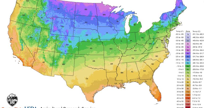
2023 USDA Cold Hardiness Zone Update

USDA Cold Hardiness Zone Map
Text and data used from:
https://planthardiness.ars.usda.gov/pages/map-creation
What’s New
This edition of the USDA Plant Hardiness Zone Map (PHZM) is GIS (Geographic Information System)-based and is specifically designed for the Internet. It enables viewers to examine plant hardiness zones at a much finer scale than 1990 and earlier maps. A very sophisticated algorithm was used to interpolate low-temperature values between actual weather reporting stations. A personal ZIP Code zone finder is also included with this version of the map. Simply type your ZIP Code in the proper box and your zone will be reported.
New Data
The edition of the USDA PHZM revised and published in 1990 was drawn from weather data from 1974–1986. The longer period (30 years) of data in the 2012 and this 2023 version of the USDA PHZM was selected by the group of horticultural, botanical, and climatological experts who led the review of the latest revision as the best balance between smoothing out the fluctuations of year-to-year weather variation and the concept that, during their lifetimes, perennial plants mostly experience what is termed "weather" rather than "climate." The 1991-2020 period also aligns with the period currently in use by climatologists to describe baseline climate “normals” in the U.S.
New Zones
Two new zones were added to 2012 and this 2023 edition of the USDA PHZM. Zones 12 and 13 have been introduced for regions with average annual extreme minimum temperatures above 50 degrees and 60 degrees F, respectively. They appear only on the maps for Hawaii and Puerto Rico. Nonetheless, the additional frost-free zones will enable better definition of conditions for tropical and semitropical plants, which often serve as house or patio plants in many parts of the country. The two new zones will provide a way to share information about differences in cold sensitivity of tropical ornamental plants and could help gardeners decide when to bring tropical plants indoors from a deck or patio as the temperature cools.
Finer Scale
Because the 2023 and 2012 maps were created digitally with GIS technology, they have a higher level of resolution and can show smaller areas of zone delineations than earlier maps. For example, cities tend to hold more heat because they encompass large areas of concrete and blacktop, so a city or town might be assigned to a zone warmer than the surrounding countryside. Higher elevations tend to be colder than surrounding lower areas, so the top of a mountain might be an area of cooler zones. A location near a large body of unfrozen water, especially downwind from prevailing breeze from that water, might provide milder winter weather and be in a warmer zone.
Climate Change
Climate changes are usually based on trends in overall annual average temperatures recorded over 50-100 years. Because the USDA PHZM represents 30-year averages of what are essentially extreme weather events (the coldest temperature of the year), changes in zones are not reliable evidence of whether there has been global warming.
Compared to the 2012 and 1990 maps, zone boundaries in this 2023 edition have shifted in many areas. The new PHZM is generally about one quarter-zone warmer than reported in the 2012 PHZM throughout much of the United States, as a result of a more recent averaging period (1976-2005 vs. 1991-2020). However, some of the changes in the zones are the results of additional data sources and improved interpolation methods. These zone shifts can sometimes result in a cooler, rather than warmer, zone. The most substantial changes produced by additional data sources and improved interpolation methods are seen in upland areas of Alaska.
Click here for more information


